
ZoomRadar has added a new feature to its embeddable weather maps: real-time tornado detection. This is the first time a web-based radar platform has integrated live tornado identification directly into radar map displays, giving users more timely and actionable information during severe weather events.
This new layer is currently available for customers on the $50/month Map plan.
Why We Built It
Developing a reliable tornado detection system is a long-term goal for us, and we’re approaching it as an ongoing effort. This new feature is powered by artificial intelligence and machine learning models trained to detect tornadic conditions using radar data in real time.
While radar overlays for warnings and storm tracks have been around for a while, the addition of automated tornado radar detection aims to add more depth and responsiveness to the radar experience—especially for organizations providing emergency services.
What Makes Tornado Detection Difficult
Tornadoes present a unique challenge in weather analysis. Compared to other severe weather events, they are:
- Short-lived, often lasting just minutes
- Localized, with highly confined impact areas
- Difficult to confirm, due to variation in radar signatures and gaps in historical records
From a data standpoint, it’s hard to build reliable models when real-world tornado observations are limited and unevenly distributed. Tornadoes are not fixed points—they’re evolving systems that can shift shape, speed, and intensity quickly. Additionally, radar coverage in the U.S. is not uniform, and timing between radar updates can vary, which makes real-time detection even more complex.
How Our Detection Works
At this stage, the system is designed to operate within tornado warning areas issued by the U.S. National Weather Service (NWS). Within these zones, our model evaluates radar data to identify signs of active tornado development.
Currently:
- The detection system updates every 4–5 minutes
- It is achieving over 90% accuracy when detecting and tracking EF2+ tornadoes
- Results appear directly on your embedded radar map, without the need for extra setup
While there are occasional false positives, we’ve chosen to err on the side of minimizing false negatives—especially when stronger tornadoes are involved. Missing a dangerous event carries more risk than flagging something that turns out not to be tornadic.
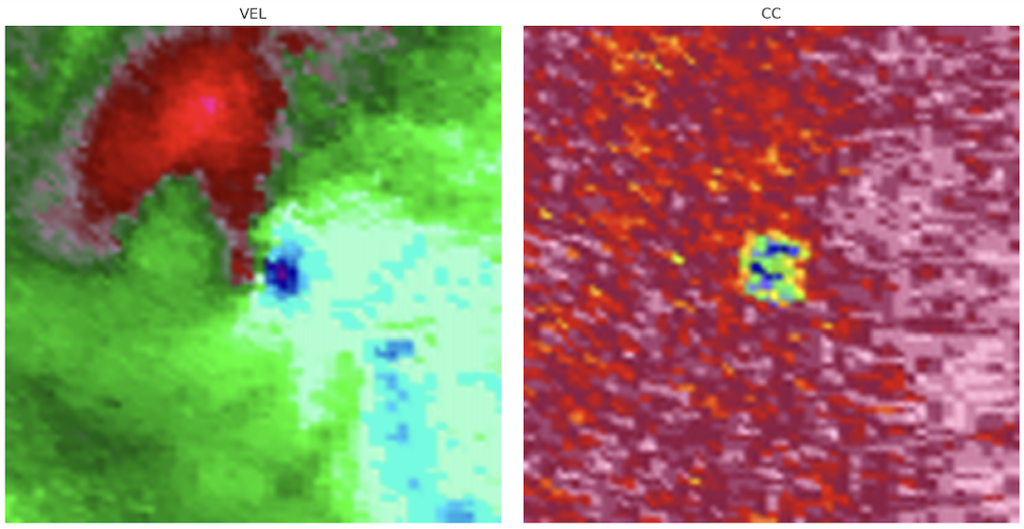
When a user hovers over a tornado detection point on the radar, additional visual context is provided. Specifically, the system will display Tornado Vortex Signature (TVS) and Tornado Debris Signature (TDS) imagery—two radar-derived products commonly used by meteorologists to assess tornadic activity. These snapshots help give a clearer picture of the radar data behind the detection, offering users more insight into what the system is identifying in that area.
About Accuracy and Limitations
Detection Rate
Our system currently detects over 90% of verified EF2 and stronger tornadoes. We continue to test and refine the model as new data becomes available.
Localization
Pinpoint accuracy is still being evaluated. Tornadoes don’t behave like single coordinates—they’re often wide, fast-moving, and highly irregular. For now, detection areas are shown within warning polygons to help convey general risk areas while we work on more precise localization.
What’s Coming Next
The current tornado detection release is a starting point. We have several feature improvements already on the roadmap, including:
- Estimating tornado width to give a better sense of the threat’s scale
- Assigning estimated EF ratings to detected systems
- Adding track history, so viewers can see where a tornado has moved—not just where it is now
- Improving detection performance, especially for weaker (EF0–EF1) events
This is a long-term project, and we expect to refine the model for years to come.
Why We’re Keeping Detection Inside Warning Areas (For Now)
Some users have asked why detections are only shown within existing NWS warning polygons. The short answer: it helps reduce false positives while the system matures.
Staying within official warning areas:
- Focuses the detection on zones already deemed high-risk by meteorologists
- Helps ensure that any displayed alerts are relevant and actionable
- Gives us more confidence in the signal-to-noise ratio of what’s displayed
Eventually, we may expand detection beyond these areas—but for now, this constraint keeps the feature usable and trustworthy.
Feedback Will Shape the Future
We’re releasing this feature early because we want feedback. Whether you’re embedding our radar on a local site, using it for live broadcasts, or tracking severe weather in real time, your input will help us improve the system.
We’re especially interested in:
- What’s useful and what’s unclear
- When false positives occur
- Any ideas for features or visualizations that could improve the experience
How to Get It
Tornado detection is now live for all users on the $50/month Map plan. If you’re already on that plan, no action is needed—tornado detections will begin showing automatically in supported areas.
If you’re on a lower-tier plan and want to explore the upgrade, visit our pricing page for details.
Final Thoughts
This feature is part of a larger effort to make weather radar more meaningful and responsive. It’s still evolving, and we’re committed to improving it over time—but we hope it’s a useful step toward giving users more insight during severe weather.
For questions, feedback, or implementation support, feel free to reach out.