
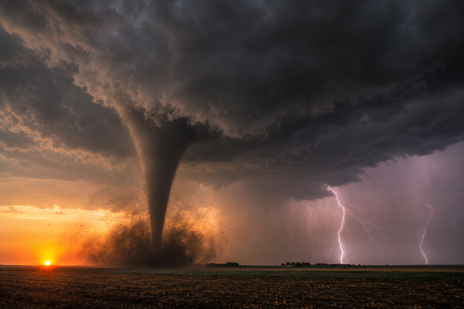
A tornado itself is too small and short-lived for radar to see directly. What radar actually detects is the storm structure around it — specific patterns that, together, tell meteorologists a tornado is likely forming or already on the ground. Here’s what those patterns actually look like, based on how the National Weather Service and NOAA’s National Severe Storms Laboratory train forecasters to read them.
Before anything else: this guide is educational, not a substitute for official warnings. Radar signatures indicate probability, not certainty. If the National Weather Service issues a tornado warning for your area, act on the warning itself — not on your own reading of a radar image.
Reflectivity vs. Velocity: The Two Radar Views
Before the specific signatures make sense, it helps to know that weather radar actually shows two different kinds of information, and meteorologists switch between them to build a full picture.
Reflectivity is the view most people picture when they think of weather radar — it shows precipitation intensity, colored from green (light rain) through yellow and red (heavy rain or hail). The hook echo shows up here.
Velocity is a different view entirely. Instead of showing how much precipitation is falling, it shows how fast that precipitation is moving toward or away from the radar. This is where rotation — the mesocyclone and the tornadic vortex signature — actually becomes visible. You can’t see wind speed and direction on a reflectivity display, no matter how closely you look; it’s simply not the information reflectivity radar captures.
Most embeddable weather radar widgets, ZoomRadar included, default to showing reflectivity, since that’s the more intuitive view for a general audience. Velocity data and the detection built on top of it typically run in the background, surfacing as an overlay or alert rather than a separate view you switch to manually.
The Hook Echo
The hook echo is the most recognizable tornado indicator, and it appears on reflectivity radar — the standard view showing precipitation intensity. It looks exactly like its name suggests: a hook or comma shape extending off the back of a supercell thunderstorm. NOAA’s National Severe Storms Laboratory explains that the hook forms from the storm’s rear flank downdraft, a specific wind pattern that wraps precipitation around the storm’s rotating core.
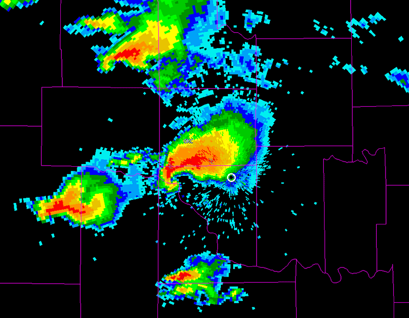
Hook echo on reflectivity radar, near Oklahoma City, OK — May 3–4, 1999 tornado outbreak. Source: NWS Norman, Oklahoma / NOAA (public domain).
Seeing a hook echo doesn’t confirm a tornado — it indicates a supercell with the kind of rotation that can produce one. It’s a “look closer” signal, not a confirmation.
The Mesocyclone and Rotation Couplet
Before a tornado forms, supercells often develop a mesocyclone — a large rotating updraft, typically 2 to 6 miles across, which is far bigger than any tornado that might eventually form inside it. You can’t see rotation on reflectivity radar; it shows up on velocity radar instead, which measures how fast precipitation is moving toward or away from the radar.
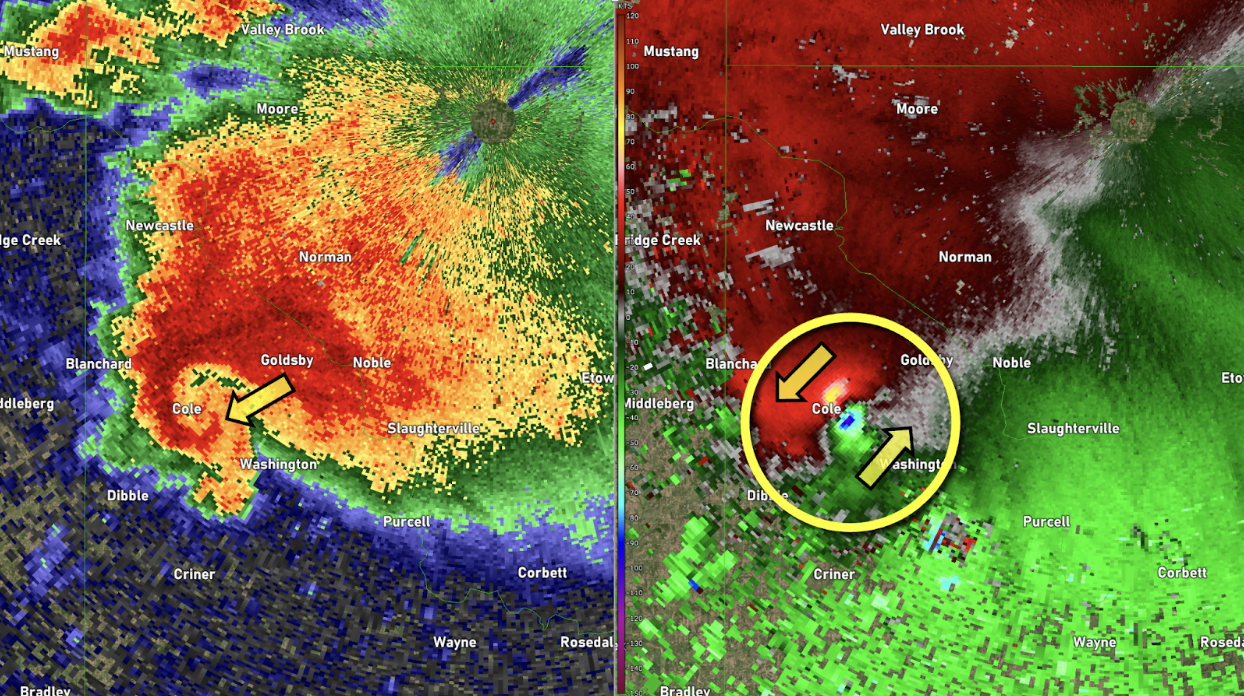
Left: reflectivity showing a hook shape. Right: velocity showing the inbound/outbound couplet (circled) — supercell near Oklahoma City, OK, April 19, 2023. Source: NOAA JetStream, noaa.gov/jetstream/velocity (public domain).
On velocity radar, a mesocyclone appears as a rotation couplet: a tight pairing of inbound (moving toward the radar) and outbound (moving away) velocities sitting right next to each other. That paired red-and-green signature is what meteorologists are looking for. NSSL’s discovery of this pattern, back in 1973, was the breakthrough that made modern tornado radar detection possible in the first place — researchers call the more intense, focused version of this signal a tornadic vortex signature, or TVS.
The Debris Signature
The most direct radar evidence of an actual tornado — as opposed to just favorable conditions — comes from dual-polarization radar, a technology built into modern NWS radars. Dual-pol can detect debris that a tornado has lofted into the air: leaves, insulation, and other scattered material with irregular shapes and sizes, distinct from the more uniform signature of rain or hail.
According to NOAA’s National Severe Storms Laboratory, this gives forecasters high confidence that a damaging tornado is actually on the ground, and it’s especially valuable at night or when rain wraps around a tornado and makes it impossible to see visually. This is called a tornado debris signature, or TDS.
How These Signatures Typically Unfold
These three signatures don’t usually appear all at once — they tend to show up in a rough sequence as a storm develops, which is part of why meteorologists watch radar continuously rather than checking it once.
A supercell first develops the hook echo on reflectivity radar, showing the storm has the rear flank downdraft structure associated with tornado-producing storms. Around the same time or shortly after, a mesocyclone becomes visible on velocity radar as a rotation couplet, and meteorologists start watching closely to see whether that rotation tightens and intensifies into a tornadic vortex signature. If a tornado actually touches down, the debris signature is often the last piece to appear, since it requires the tornado to already be lofting material into the air.
This sequence is exactly why a single radar signature is never treated as the whole story. A hook echo alone might dissipate without ever producing a tornado. A rotation couplet might strengthen and then weaken again. It’s the combination and progression of these signatures, watched over time, that gives forecasters confidence — not any one signature in isolation.
How ZoomRadar Displays These Signatures
ZoomRadar’s tornado detection model looks for this same combination of patterns — rotation and debris signatures — evaluating radar data for tornadic signals rather than requiring you to read raw reflectivity and velocity data yourself. When ZoomRadar’s model flags a detection, hovering over it reveals the underlying radar imagery: the actual TVS and TDS snapshots behind that specific alert, so you can see the same evidence a meteorologist would look for, rather than just a generic warning icon.
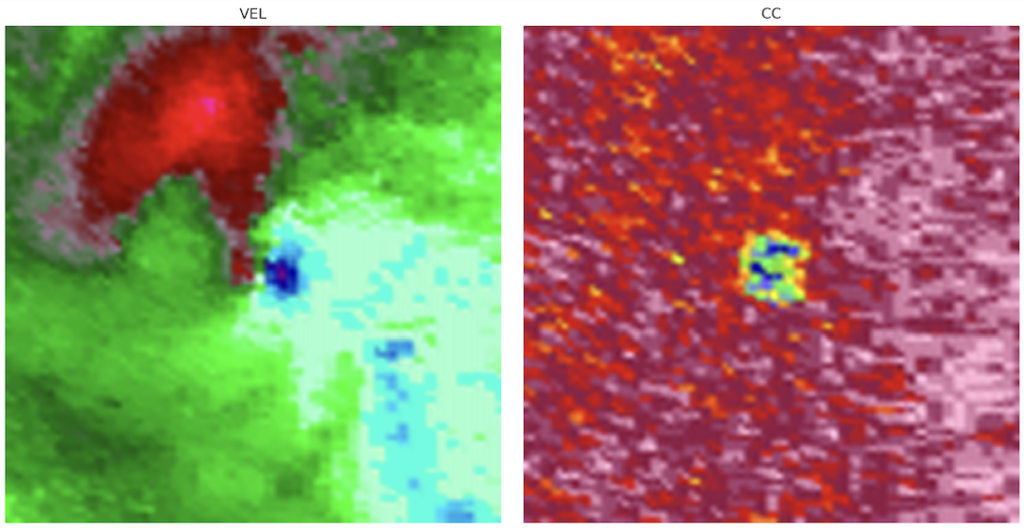 ZoomRadar’s tornado detection feature, showing the TVS and TDS radar imagery revealed when hovering over a flagged detection. Source: ZoomRadar.
To reduce false positives, ZoomRadar currently displays its detections within official NWS tornado warning polygons rather than as independent, standalone alerts — pairing its own radar-pattern detection with the National Weather Service’s official warning process rather than replacing it.
Frequently Asked Questions
What does a tornado look like on radar?
There’s no single “tornado shape” on radar. Instead, meteorologists look for a combination of signatures: a hook echo on reflectivity radar, a tight rotation couplet on velocity radar, and — when a tornado is actually on the ground — a debris signature from dual-polarization radar showing debris the tornado has lofted into the air. ZoomRadar’s own detection model looks for this same combination of signatures.
How does radar display tornado rotation and what should I look for?
Rotation shows up on velocity radar, not standard reflectivity radar, as a rotation couplet — paired inbound and outbound velocity readings sitting right next to each other. A tighter, more intense version of this pattern is called a tornadic vortex signature, which is exactly what ZoomRadar’s detection model looks for.
Can radar confirm a tornado is on the ground, or just that conditions are favorable?
Both, depending on the signature. A hook echo or rotation couplet indicates favorable conditions for a tornado, not confirmation. A debris signature from dual-polarization radar is much stronger evidence, since it detects actual debris a tornado has lofted into the air once it’s already touched down. This is the stronger of the two signatures ZoomRadar’s detection model displays when it flags a detection.
Does ZoomRadar show these radar signatures directly?
Yes. When ZoomRadar’s tornado detection model flags a potential tornado, hovering over the detection reveals the underlying radar imagery — the same rotation and debris signatures described in this guide — rather than just a generic alert icon.
What’s the difference between reflectivity and velocity radar?
Reflectivity shows precipitation intensity — how heavy rain or hail is falling. Velocity shows how fast that precipitation is moving toward or away from the radar, which is where rotation signatures like the mesocyclone and tornadic vortex signature actually become visible. The hook echo appears on reflectivity; rotation signatures appear on velocity.
Do all tornadoes produce a hook echo on radar?
No. A hook echo depends on a specific storm structure — a supercell with a rear flank downdraft — and not every tornado-producing storm develops one clearly. Weaker or fast-moving tornadoes, and tornadoes from storm types other than supercells, may not show a textbook hook echo even while producing real damage on the ground.